Tuesday was the parks meeting for Richmond council for March. The Garden City Lands inched ahead, a welcome turn of events.
For things to speed up, farm roads on the lands are key. They could be called something else, but “farm road” is apt, and our central park is an ALR farm. If it weren’t, it couldn’t have come to be a park. As you may recall, it was to be a construction zone until the people and the Agricultural Land Commission said “No!”
The main farm road for now is the perimeter trail. It will be a low dyke too. The roles of service road, public trail and water dyke are all key in their own ways.
People always want me to describe how things will be. This time I’ll answer, but it’s just an informed guess. (It’s up to city planners to plan.)
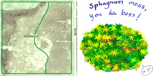
Look at the satellite view of the Garden City Lands, which are wet. The darker parts are the wetter ones, the lower ones. In the northwest corner at top left, there’s a wide berm. It’s the highest and driest part of the lands because the commission once let 50,000 cubic metres of clean clay fill be placed there.
The line drawn all around, near the edge of the image, gives a sense of the perimeter trail. It’s a farm road-dyke-trail that we can see as we look into the future. It consists of clean clay fill, like the northwest berm that in effect is part of it.
The durable surface is typically five metres wide. Some parts are wider to allow service vehicles to turn around and people to sit and chat and learn from interpretive signs.
We (in the future) use the trail to get around on foot or maybe by mobility scooter or bike. It’s pleasant to be a bit away from the arterial roads that surround the lands.
Outside the trail on the north edge, there’s a ribbon of woods. It can’t restore the senseless loss of natural viewscape across Alderbridge Way, but it lessens the scar.
On the east edge beyond the trail, there’s a gravel parking lot. It’s inside the No. 4 Road fence and above the water-system conduits. Better there than elsewhere.
As a dyke, the perimeter trail enables water management. That’s vital for every use of the park. The older ditch along Westminster Highway and stormwater drains along Garden City Road are outside the dyke to take the road runoff. They’re also useful when water is let out from the lands to drain a section.
The north-south line curving through the satellite image represents a similar farm road-dyke-trail. There will be others, but that one is crucial for another legacy, the sphagnum moss bog. Looking east from the new trail, we see an ecosystem that is abused and fragile but still restorable.
The trails around the sphagnum bog on the east side of the lands keep precipitation in, enabling a high water table, an essential for recovery. They also keep out water with unwelcome nutrients and the alkalinity that’s better for agriculture. Sphagnum likes acidic water, which it helps create in a natural way.
Sphagnum moss, a marvel of nature, is the keystone species of the bog ecosystem, which once took in a large area of Lulu Island. Progress has meant decline until there’s just the one bit left (except on off-limits federal land). The farm road-dyke-trails may save the legacy.
Long ago, sphagnum moss formed the land, and the native bog plants still depend on it. It deserves a better life and its own column. For now, it’s got its own cartoon.
_____
This article appeared on March 28, 2014 as a column in my Digging Deep series in the Richmond Review. It was titled “The multi-gift trails of our central park.”


Leave a comment